


Voting District 1200024, Monroe County, New York
About
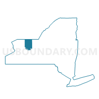
Outline

Summary
| Unique Area Identifier | 630282 |
| Name | Voting District 1200024 |
| County | Monroe County |
| State | New York |
| Area (square miles) | 0.47 |
| Land Area (square miles) | 0.47 |
| Water Area (square miles) | 0.00 |
| % of Land Area | 100.00 |
| % of Water Area | 0.00 |
| Latitude of the Internal Point | 43.16196900 |
| Longtitude of the Internal Point | -77.48878400 |
Maps


Graphs
Select a template below for downloading or customizing gragh for Voting District 1200024, Monroe County, New York


Neighbors
Neighoring Voting District (by Name) Neighboring Voting District on the Map
- Voting District 1200006, Monroe County, NY
- Voting District 1200012, Monroe County, NY
- Voting District 1200015, Monroe County, NY
- Voting District 1200017, Monroe County, NY
- Voting District 1200020, Monroe County, NY
- Voting District 1200025, Monroe County, NY
- Voting District 1200033, Monroe County, NY
Top 10 Neighboring County Subdivision (by Population) Neighboring County Subdivision on the Map
Top 10 Neighboring Unified School District (by Population) Neighboring Unified School District on the Map
Top 10 Neighboring State Legislative District Lower Chamber (by Population) Neighboring State Legislative District Lower Chamber on the Map
Top 10 Neighboring State Legislative District Upper Chamber (by Population) Neighboring State Legislative District Upper Chamber on the Map
Top 10 Neighboring 111th Congressional District (by Population) Neighboring 111th Congressional District on the Map
Top 10 Neighboring Census Tract (by Population) Neighboring Census Tract on the Map
- Census Tract 115.04, Monroe County, NY (6,317)
- Census Tract 115.03, Monroe County, NY (6,060)
- Census Tract 116.04, Monroe County, NY (2,285)
- Census Tract 116.05, Monroe County, NY (2,098)